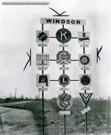
Another old Newspaper photo, this one today is dated March 8, 1957.
It’s from the Detroit News, and the caption on the back, reads as follows:
According to the notes on the back of the photo, it ran in the March 27, 1957 issue on the “pix page”.

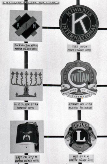
Looking at some of the clubs and where they met. Most are long demolished or have changed names. The Norton Palmer and Prince Edward hotels both long ago met the wreckers ball… The Elmwood is now Brentwood, and the Majestic Restaurant where Civitan International met, is better known today as Tops on Ottawa Street.
Have a safe weekend everyone, see you back here Monday.
_______________________________________________________________________________________________

The club signs are very interesting, especially the didactic listing of meeting locations. This is how “community” was formed, long before the internet. Mind, the clubs were a particular slice of Windsor (what kind of organizations would never be allowed to put up a sign there announcing its existance, in 1957) but still neat.
I’m trying to figure out the chevron shaped elements seeming to ‘float’ around sign perimeter.
Those are photo-editor crop markings.
shawn is correct. those are the crop marks. everything inside the marks is what appeared in the print issue.
Is that Dougall road in the back ground? Right where is Shoppers and the Gym is now.
Thanks for asking GH. I was puzzled too.
King’s highway #2 is what we now know as county road 42 – i.e. the road past the airport. I don’t recall if Howard Ave. was considered #2 or if it was Walker. It’s hard to tell where this sign was because a lot of changes have taken place, including amalgamation in the 60’s. Dougall road was highway #3b.
I took the picture and zoomed in for a closer look. In the far background, to the left and extending away to the right, there are railroad tracks. If this is indeed Highway 2, those are the Michigan Central RR tracks. Taking into account the year and the known re-engineering of the roads in that area, I would say that this photo was taken near what is now the southern-most end of Windsor Memorial Gardens Cemetery, looking toward where the Provincial Chrysler dealership is now.
Howard Av. was probably highway #2, coming to Windsor past Walker Rd. #2 curved to the right near the cemetery,on to Howard Av.. Coming out of Windsor if you past Cabana, past Walker (now called Provincial Rd.) it turned into highway #98, whitch went east south of Tilbury to Ridgetown and east.Highway # 2 went througth Tilbury north of the NYC tracks to Chatham, on to London.
#2 highway (Division Rd – County Rd 42) terminated at Howard Avenue just north of where The Keg is today. #98 highway (Provincial Rd – County Rd 46) ended and teed into #2 highway very near where the picture was taken. This became a traffic nightmare in later years, hence the re-engineering. Evidence of some of the earlier changes is still there in the tall grass. This was all prior to 401 being built making #2 the main highway in and out of Windsor to Toronto. That is why there are (were) so many motels on Howard, south of Eugenie.
from http://www.thekingshighway.ca/PHOTOS/Hwy2photos2.htm which shows a photo of Ouellette Ave in 1951 with the following information:
“Note the signpost at right, which bears no fewer than four King’s Highway shields. Although the route numbers are difficult to discern in this photo, the four marked routes are Hwy 2, Hwy 3B, Hwy 39 and Hwy 98. For a number of years, all four of these King’s Highways were signed concurrently along Ouellette Avenue into Downtown Windsor. However, due to the construction of the E.C. Row Expressway and the decommissioning of Hwy 39 and Hwy 98, three of these highway routes were eventually removed from Ouellette Avenue. Only the Hwy 3B route designation survived until the 1990s.”
So in the 50s Hwy 2 continued down Howard to Tecumseh, then West to Ouellette, then North to the riverfront and connected with hwy 18.
More highway history (routes, numbering and renumbering through the years can be found at http://wapedia.mobi/en/Highway_98_(Ontario)
Just spent the better part of 10hrs on 401, 404, and #8. Wow JBM…great links. I grew up about half a mile due west of that sign. I would have been 5yrs when that picture was taken. We lost a lot of our heritage highways when Mike Harris got involved.
Lots of info on ‘defunct’ highways can befound from this starting point:
http://en.wikipedia.org/wiki/Category:Defunct_Ontario_provincial_highways
I was amazed to discover that what most people knew as highway #2 from Tilbury to Windsor (now Cty Road 42) was at one time Hwy 18.
I’d be “amazed” to hear that too. Where exactly did you read that, JBM?
John, from http://wapedia.mobi/en/Highway_98_(Ontario) :
“Before 1929, Highway 18 connected Windsor to Tilbury along today’s County Road 42/Division Road, while Highways 2 and 3 were concurrent along Ouellette Avenue from the Ferry Docks (located between Howard Avenue and Ouellette Avenue) to Talbot Road. They split company at Maidstone (today’s junction of County Road 34 and Former Highway 114). Highway 3 would continue through Essex, Ontario to Leamington and points east, while Highway 2 followed Malden Road (Former Highway 114) to Middle Road (What would become Highway 2A, then Highway 98, ultimately today’s County Road 46).”
Well JBM….this site certainly has some very facinating reading. However…some of the arterial, geographical, and municipal connections mentioned would lead me to take these references with a large grain of salt. In particular, the notes on Howard Ave. It is current enough to know of the recent upgrades at Cabana Rd., yet makes reference to Aylmer and Glengarry and gets their direction of traffic flow wrong.
I’m not saying they’re a lot hogwash, they just make me want to say hhmmmmmmmm.
thanks for that link JBM – I love that picture of Ouellette above the quote you made at 6:36.
holy tree-lined street batman!
This may be a stange question but prior to the mass annexation in 1966, where was the city order on Howard Ave?On Dougal Av. the border was near the CPR tracks, Dorwin Plaza was in Sandwitch West Township. Also was Walker Rd. border the CPR tracks?
Prior to 1966, the CPR tracks were roughly the southern border of Windsor from west of Dougal to somewhere around Walker road. Sandwich West township was south of the CPR tracks and west of Howard. Sandwich West was bordered on the east by Howard out County Road 8, otherwise North Town line. Sandwich East township was south of the tracks and east of Howard out to Cabana Road. I don’t know where the eastern boundary of Sandwich East was, but perhaps it went as far as Tecumseh town. Sandwich South township north boundary included Cabana road partially, while Howard was the westerly boundary. The southern boundary might have been the easterly extension of Cty. Rd. 8. Both Sandwich East and South bordered Malden township some where to the east. This has been a bit much I guess but I just got rolling on it !
Woops! In my post about township boundaries, I suffered a brain freeze and moved a township. The eastern border for Sandwich South should be with Maidstone Township.
If I read the description of the Windsor boundary on the south, in 1957 the service club sign was in Sandwitch West township, if it is on the curve by the cemetery or south of the NYC crossing on Howard Av/